Navionics NAV-MSD/2XG Gold All Canada on SD/microSD Card
Feature
- Two-Dimensional marine charts on SD/microSD cards
- Tides and currents
- Port plans
- Coastal roads
- Marine services
Product Description
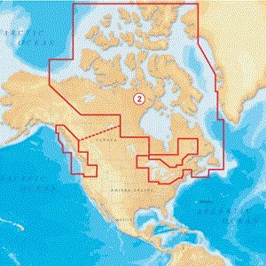
Coverage area: St. Lawrence River, Lake Champlain, Gulf Of St. Lawrence, Nova Scotia, Labrador, Newfoundland and Nunavut - From Cornwall and Montebello to Bay of Fundy to Lake Champlain, including Sable Island, Iles De La Madeleine, Prince Edward Island, Anticosti Island, Cape Breton Island, Iles De La Madeleine and Strait of Belle Isle, Puget Sound, British Columbia, Vancouver Island, Southeast Alaska- From Siuslaw River in Oregon to Lituya Bay in Southeast Alaska including Columbia River Puget Sound, Juan de Fuca Strait, Strait of Georgia, Johnstone Strait, Queen Charlotte Strait, Cape Flattery, Hecate Strait and Queen Charlotte Islands, Entire Great Lakes, St. Lawrence and the Canadian Maritimes - Including Lake of the Woods, Rainy Lake, Lake Champlain, Trent Severn Waterway, Ottawa River, Rideau Waterway and the Finger Lakes.
Product Detail
- Product Dimensions: 5.6 x 0.6 x 7.5 inches; 0.05 pounds
- Shipping Weight: 0.05 pounds
- ASIN: B0033YGHXE
- Item model number: MSD/2XG
- Average Customer Review: Customer Reviews
Customers Who Viewed This Item Also Viewed
New
More Details


About Us

Free Shipping
If your order is $35 or more, you may qualify for free shipping. With free shipping, your order will be delivered 5-8 business days.

