Navionics MSD/NAV+NI Navoincs +
Feature
- Choose your coverage area online
- Contours up to 1 ft./0.5 m
- Daily updates and advanced features for one year
- Download Nautical Chart, Sonar Chart and Community Edits
- Enhance Sonar Chart with sonar logs you collect
Product Description
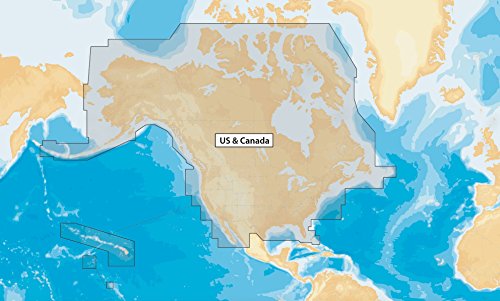
Boat safer and fish smarter. Max-detailed cartography for marine and lakes that is updated daily, makes Navionics+ the perfect choice for cruising and fishing. Get Nautical Chart, the most accurate navigational data; Sonar Chart, an exclusive 1 ft. HD bathymetry map; and Community Edits, local content from the community. Simply plug this card into your PC/Mac, go to navionics.com and choose from: Africa & Middle East; Australia & New Zealand; Baltic Sea; Caribbean & South America; Central & West Europe; China Sea & Japan; Greenland & Iceland; Indian Ocean & S. China Sea; Mediterranean & Black Sea; Norway; Pacific Islands; Russia West; Skagerrak & Kattegat; UK, Ireland & Holland; US & Canada. Daily updates and advanced features are included for one year. USB reader provided.
Product Detail
- Product Dimensions: 1 x 0.1 x 1 inches; 0.22 pounds
- Shipping Weight: 0.22 pounds
- ASIN: B00AU6IQ5K
- Item model number: MSD/NAV+NI
- Average Customer Review: Customer Reviews
Customers Who Viewed This Item Also Viewed
New
More Details
About Us

Free Shipping
If your order is $35 or more, you may qualify for free shipping. With free shipping, your order will be delivered 5-8 business days.

