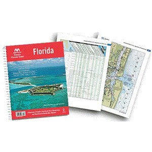
Maptech Embassy Cruising Guide – Florida
Feature
- Florida and the Bahamas, 4th Edition
- Complete coverage of Florida's East Coast, Gulf Coast to Mobile, AL, the Florida Keys, the Okeechobee Waterway, and a planning guide and facility listing for the Bahamas. Features detailed navigation advice, aerial photos, destination and dining tips, comprehensive bridge tables, GPS waypoints, and detailed listings for 1,300 marine facilities. 560 pages.
- Features detailed navigation advice, aerial photos, destination and dining tips, comprehensive bridge tables, GPS waypoints, and detailed listings for 1,300 marine facilities.
- 560 pages.
Product Description
Embassy Cruising GuidesBKFLFloridaUpdated AND expanded! Waterways of Florida's East Coast, Keys, Okeechobee, and West Coast to Mobile Bay, Alabama. Over 1,400 marine facilities; detailed navigation advice. All new aerial photos, destinations, bridge tables, GPS Waypoints. 624 pages.Product OverviewEmbassy Guides are the perfect navigation companion when you're planning your trip and underway. They're filled with detailed navigation advice and are an enjoyable read. Maptech offers four guides covering the East Coast of the U.S. from Maine to Florida, plus the Bahamas and Alabama. Designed for Ease of Use Find the information you need quickly. Harbors are indexed by chapters. Marina and facility locations cross-reference quickly with harbor chart segments. Even the crush-proof spiral binding and wrap-around covers are designed for easy page turning and bookmarking."Local Knowledge" The writers and editors have traveled everywhere they write about. Detailed navigation advice will help you approach new harbors as if you're a local. Complete Marina Information Marine facilities tables display key information that allows you to find the "right" facility quickly. Facility tables are cross-referenced to harbor chart segments so you can locate the facility easily. Harbor Chart Segments Full-color harbor chart segments show marina approaches and display the locations of facilities in relationship to each other. Aerial Photos and Pictures Bird's-eye Aerial Photos of harbor entrances improve your situational awareness during approaches. Beautiful pictures highlight local landmarks and the vistas you may see while underway or at anchor.
Product Detail
- Product Dimensions: 11 x 10 x 1 inches; 3.6 pounds
- Shipping Weight: 3.6 pounds
- ASIN: 0743609999
- Item model number: BKFL-03
- Average Customer Review: Customer Reviews
Customers Who Viewed This Item Also Viewed

New
More Details
New
More Details
About Us

Free Shipping
If your order is $35 or more, you may qualify for free shipping. With free shipping, your order will be delivered 5-8 business days.

