Lake St. Clair Fishing
Feature
- Two Sided
- Foldable
- Tear Resistant Synthetic Paper (Hop-Syn) 5 PP Tree Friendly
Product Description
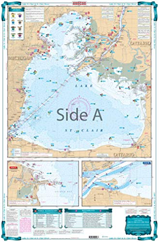
Complete coverage of Lake St. Clair on side "A" with detailed insets of the Detroit River entrance and the entrance to the Clinton River. Side" B" has complete coverage of the St. Clair River north to Lake Huron with a detailed inset of Port Huron. Nautical information derived from 3 NOAA Charts; #14852, #14853 & #14850. This LARGE PRINT Lake Chart details all of the Major Fishing Areas and pinpoints dozens of specific areas for the major species caught in the area. (Large and Smallmouth Bass, Yellow Perch, Walleye, Muskie, Northern Pike, Salmon & Trout). Many areas have GPS positions. In addition many popular restaurants are listed as well as popular Boat Ramps. If you're serious about fishing Lake St Clair, this is a "Must Have". Chart is 25" X 38". WGS84 - World Mercator Datum.
Product Detail
- ASIN: B00C34UE7U
- Item model number:
- Average Customer Review: Customer Reviews
Customers Who Viewed This Item Also Viewed


New
More Details
About Us

Free Shipping
If your order is $35 or more, you may qualify for free shipping. With free shipping, your order will be delivered 5-8 business days.

