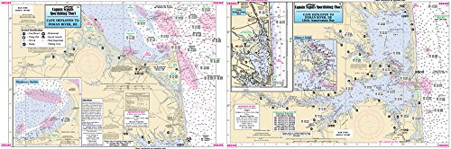
Captain Segull’s Small Boat Rehoboth Bay & Indian River Delaware Nautical Chart
Feature
- Captain Segull's Small Boat Rehoboth Bay & Indian River Delaware Nautical Chart
Product Description
Captain Segull's Small Boat Rehoboth Bay & Indian River Delaware Nautical Chart
Small Boat/Kayak Inshore fishing chart, double sided, laminated, 12 x 18 inches, Delaware
Detailed chart from Broadkill River east to Cape Henlopen south to Bethany Beach with details in Rehoboth Bay and Indian River and Indian River Bay. Now an inset of Little Assawoman Bay. All charts include GPS coordinates, wrecks, reefs, shoals, fishing areas, amenities and restrictions.
Chart #RB305
Product Detail
- Product Dimensions: 0.81 pounds
- Shipping Weight: 0.81 pounds
- ASIN: B00JKOGH3Q
- Item model number:
- Average Customer Review: Customer Reviews
Customers Who Viewed This Item Also Viewed

New
More Details
New
More Details
About Us

Free Shipping
If your order is $35 or more, you may qualify for free shipping. With free shipping, your order will be delivered 5-8 business days.

