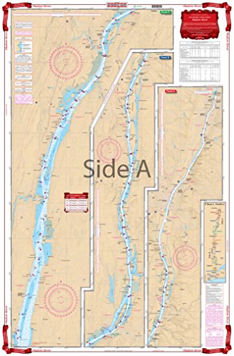
57 Waterproof Navigation Chart of Hudson River
Feature
- Two Sided
- Foldable
- Tear Resistant Synthetic Paper (Hop-Syn) 5 PP Tree Friendly Two Sided Foldable
Product Description
The complete river from New York city to Albany on a single sheet! Starting at the George Washington Bridge, this chart covers the entire river north through Nyack, Peekskill, West Point, Poughkeepsie, Catskill, Hudson and through Albany to the Federal Locks at Troy. Color Keyed Panels make the chart easy to read and understand and large print place names make areas easy to find. Information from 3 NOAA Charts, including 12348. WGS84-World Mercator Datum. Free Update Service provided by this vendor (proof of purchase required). 25" x 38".
Product Detail
- ASIN: B001GAG2MS
- Item model number: SG_B001GAG2MS_US
- Average Customer Review: Customer Reviews
Customers Who Viewed This Item Also Viewed


New
More Details
New
More Details
About Us

Free Shipping
If your order is $35 or more, you may qualify for free shipping. With free shipping, your order will be delivered 5-8 business days.

