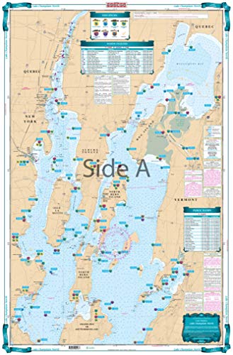
Waterproof Charts, Lake Fishing, 12F Lake Champlain North
Feature
- Two Sided
- Foldable
- Tear Resistant Synthetic Paper (Hop-Syn) 5 PP Tree Friendly
Product Description
This LARGE PRINT Lake Chart details all of the Major Fishing Areas and pinpoints dozens of specific areas for the major species caught in the area. (Large and Smallmouth Bass, Yellow Perch, Walleye, Muskie, Northern Pike, Salmon & Trout). Many areas have GPS positions. Grass and Marsh areas are also identified. Marinas are listed as well as popular Boat Ramps. Starting at Willsboro and Shelburne Points coverage is north to and including Missisquoi Bay and the Rt 202 Bridge on the Richelieu River in Canada. Includes Malletts Bay and all of the Champlain Islands. Information from 2 NOAA Charts: #14782 & #14781. Chart is 25" X 38". WGS84 - World Mercator Datum.
Product Detail
- ASIN: B00C34T8J0
- Item model number:
- Average Customer Review: Customer Reviews
Customers Who Viewed This Item Also Viewed
New
More Details
New
More Details

About Us

Free Shipping
If your order is $35 or more, you may qualify for free shipping. With free shipping, your order will be delivered 5-8 business days.

